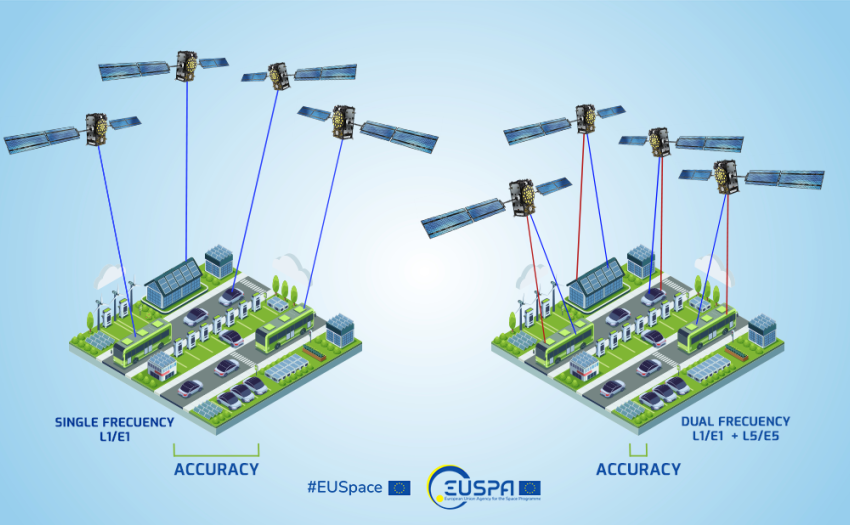
GSA initiative targets post-COVID urban sustainability: we want to hear from cities

Published: 
13 July 2020
A survey has been launched to assess the needs of urban mobility stakeholders.

The GSA aims to help cities emerge stronger from the COVID-19 pandemic by leveraging EGNSS (Galileo and EGNOS) and Copernicus synergies to make urban mobility more sustainable, as well as boost innovation and economic growth. To do this, the GSA is creating a network of cities that have decided to build better, more sustainable and efficient transport systems to support the recovery phase. With this in mind, a survey has been launched to understand the needs and develop tailored awareness raising and support actions on space for cities. The Horizon 2020 Ariadna project will take it further with dedicated support to facilitate the use of space for sustainable cities and its integration into new urban mobility schemes.

Transport represents almost a quarter of Europe's greenhouse gas emissions and is the main cause of air pollution in cities1. While Europe recovers from the COVID-19 crisis and lockdown measures are lifted, the demand for mobility is cautiously increasing. In this context, some cities have decided not to ‘return to normal’, but to take the opportunity to build a better, more sustainable and efficient transport system to support the recovery phase2.

Key role for space

Urban mobility is undergoing a profound transformation, with new mobility services and innovations allowing people to easily mix and match different modes of transportation. Space services are playing a key role in the modernisation of cities and urban transport, opening new possibilities to exploit the synergies of Galileo and Copernicus to go green. However, urban areas are obstacle-rich environments generating a “multipath effect” that results in reduced positioning accuracy.

Read this: European GNSS supports smarter mobility

But, by using Galileo capabilities in multi-frequency solutions the accuracy and time to fix a position is significantly improved. This is translated into a better location for vehicles, which is key to optimising network planning. Copernicus services can support emissions monitoring by validating the measurements from existing sensors and extrapolating data to areas not covered otherwise. They also provide advanced imagery to support urban planning and monitoring of activities in a city. 

Space4Cities: Cities, speak up!

The H2020 Ariadna project will support all urban mobility stakeholders in ensuring that public transport delivers urban mobility in its broadest sense, which includes shared mobility and disruptive schemes such as Mobility as a Service (MaaS) using EGNSS and Copernicus. Together with Ariadna, the GSA is launching an initiative to bring cities that want to go greener and are looking for answers from space data together in the Space4Cities network.

And this: Satellites and the City

To facilitate this process, the European GNSS Agency (GSA) and Ariadna have launched a survey to identify which cities would like to engage with the initiative, assess their needs and how EGNSS and Copernicus services and data can best help them to achieve their sustainable mobility goals. The survey will only take five minutes to complete – you can find it here.

What’s next: Ariadna support to sustainable cities

Ariadna aims to engage with a comprehensive range of stakeholders, covering cities and the entire urban mobility value chain. These include public transport authorities, cities, research centres, technology providers, SMEs and start-ups and end users. Following the results of the survey and the interest from the partner cities, the project will provide dedicated support through tailored workshops to increase awareness on the use of Galileo and Copernicus to improve urban transport. Specifically, awareness will be raised on Galileo’s enhanced features for accurate and authenticated positioning, as well as synergies with Copernicus, to monitor the relevant indicators that can support the development of new sustainable urban mobility plans.

To stay up to date on news from Ariadna, follow the project on social media.

Media note: This feature can be republished without charge provided the European GNSS Agency (GSA) is acknowledged as the source at the top or the bottom of the story. You must request permission before you use any of the photographs on the site. If you republish, we would be grateful if you could link back to the GSA website (http://www.gsa.europa.eu).

Updated: Dec 08, 2022