EGNOS for Mapping: New Video Released
Disclaimer
This page has been archived and is provided for historical reference purposes only. The content and links are no longer maintained and may now be outdated.

You have already seen how EGNOS is used on the Road, in Agriculture and in the Aviation industry. Now it's time to take a closer look at how EGNOS is used for Mapping.
 EGNOS offers outstanding reliability and data integrity and can contribute in growing the use of GNSS in real time mapping solutions by providing free accuracy that is widely available.
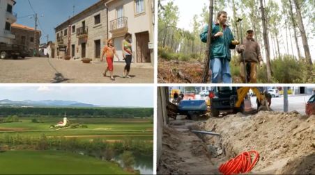
One of the main benefits of EGNOS for mapping is accuracy. This is a huge selling point for users like Lena Esteves, Director of Gardunha Verde Biodiversity Project in Portugal. According to her, “accurate mapping is very important to us, because we need to develop very detailed plans for the national authorities, such as the Ministry of Agriculture and the National Authority for Forestry.”
Forestry owner José Manuel Duarte has been using EGNOS for few years now and has found it meets his needs because the mapping is very close to the actual situation, with a margin of error “from about 50 cm to a metre.”
The accuracy of EGNOS is further enhanced with EDAS, the EGNOS Data Access Service, which provides the correction signal through regular mobile data connection. Johannes Hotz of Leica Geosystems says, “with this service, you simply connect to the Internet, receive the EGNOS corrections via TCP/IP and it gives our customers an opportunity to get EGNOS corrections everywhere in Europe.” Corrections are applied in real time and it therefore eliminates the need to spend time on post-processing.
Accurate data at no cost
 Cost efficiency is a second key strength of the EGNOS system. Because its signal is free of charge, it enables mapping solutions without the need for paid subscriptions, as is the case with other similar services.
Paulo Fernandes, Mayor of Câmara Municipal do Fundão in Portugal, introduced EGNOS in his municipality some time ago and immediately noticed the savings it produced. According to him, traditional surveying was 5 to 6 times more expensive than the GNSS system they use today.
In addition to accuracy and cost effectiveness, ease of use is a strong incentive for employing EGNOS. For starters, there is no need for buying new equipment. All hardware with built-in receivers can be used with EGNOS and therefore there is no need for unnecessary expenses.
Sound interesting? Watch the full video about EGNOS for Mapping