Secure SATCOM
Secure Satellite Communications enable security- and safety-critical missions and operations, including crisis management, land and border surveillance and protection of the key infrastructure.
Secure satellite communications (SATCOM) are essential for the resilience and strategic autonomy of the EU and its Member States ensuring the daily functioning of the EU digital economy and critical governmental services.
Secure SATCOM is a fundamental communications layer enabling security- and safety-critical missions and operations, including crisis management, land and border surveillance and protection of the key infrastructure across the whole EU economy sectors.
The satellite communications sector has witnessed profound transformation driven by new market entrants and the emergence of multi-orbital constellations catering to diverse user demands in fixed, mobile, aero, and maritime applications. Innovations in satellite technology have led to higher throughput, lower latency services and enhanced security. This revolution is happening thanks to many novelties in the ground and space segments: new manufacturing methods, the introduction of higher frequency bands, the development and deployment of Very High-Throughput Satellite (VHTS) Systems in all orbits (GEO, MEO, LEO), the implementation of new technologies enabling very high and efficient configurability of communication payloads and their ground segment and the rise of optical communications and quantum encryption techniques. This development of cutting-edge technologies in novel space and ground segment systems has boosted innovative applications that agile New Space players are embracing to implement services benefiting multiple vertical market segments in both the public and private sectors.
Considering the increase of geopolitical instability, climate change disasters and the uprising of cyber threats, Secure SATCOM is an essential layer more relevant than ever to enable and ensure the continuity of services across all the vertical markets for governments and businesses in the EU with an augmented resilience and security., As a consequence of this significant increase in the overall challenges faced, the demand for secure SATCOM is on the rise.
In particular, the use of SATCOM supporting Crisis Management, Surveillance, and Key Infrastructure in the EU is estimated to increase by a factor of 14 between 2025 and 2040, reaching around 186 Gbps by 2040 (Fixed Satellite Services only).
GNSS and Secure SATCOM User Technology Report
The EU is working on the deployment of the GOVSATCOM Hub, a unique innovative critical infrastructure of this secure SATCOM layer in charge of orchestrating the sharing and polling of key secure communication capabilities, including the space asset resources from the ambitious IRIS2, the new EU Secure Connectivity Programme. GOVSATCOM Hub coupled with IRIS2 will provide new innovative and essential secure satellite communication pillars to the EU Member States to efficiently address the growing demands of secure applications mentioned and complement those of the existing EU Space Programme components for Navigation (Galileo and EGNOS), Earth Observation (Copernicus) and Space Situational Awareness.
Galileo
Europe’s Global Navigation Satellite System (GNSS), Galileo provides accurate, reliable and precise positioning, navigation, timing and safety services to over 4 billion users worldwide.
Galileo, the EU´s Global Navigation Satellite System (GNSS), provides improved navigation, positioning and timing information. Unlike other global satellite navigation systems, Galileo is a civilian system – it was conceived with secure service provision to end users at its core.
Galileo is designed to enable various satellite-based services and applications for a broad spectrum of sectors and users, ranging from aviation and maritime to agriculture and location-based services, providing Europe and European citizens with independence and sovereignty in the provision of positioning services.
As the world’s most precise GNSS programme, Galileo provides numerous benefits to businesses and billions of users worldwide. For example, when embedded in everyday products such as in-vehicle navigation devices and mobile phones (4.5 billion), Galileo ensures that users know their exact position with greater precision and accuracy than other available systems.
The services offered by Galileo are also being leveraged to help make Europe’s transport means safer and more efficient. Furthermore, these services are critical in the fight against climate change, playing a crucial role in helping Europe achieve key policy initiatives as the EU Green Deal and Digital Transformation.
Galileo also supports emergency first responders in their search and rescue efforts. Finally, by enhancing European innovation, Galileo plays a pivotal role in fostering the development of new products, services and jobs.
Programme
The Galileo Programme is owned by the EU. The European Commission has overall responsibility for the programme, managing and overseeing the implementation of all activities on behalf of the EU.
Galileo's design and system evolution, along with the technical development of its infrastructure, are entrusted to the ESA. The European Commission has delegated the operational management of the programme to EUSPA, which is responsible for the deployment, maintenance and minor evolutions of the Galileo system, and that oversees how the Galileo infrastructure is used, ensuring that Galileo services are delivered with the defined performance and without interruption.
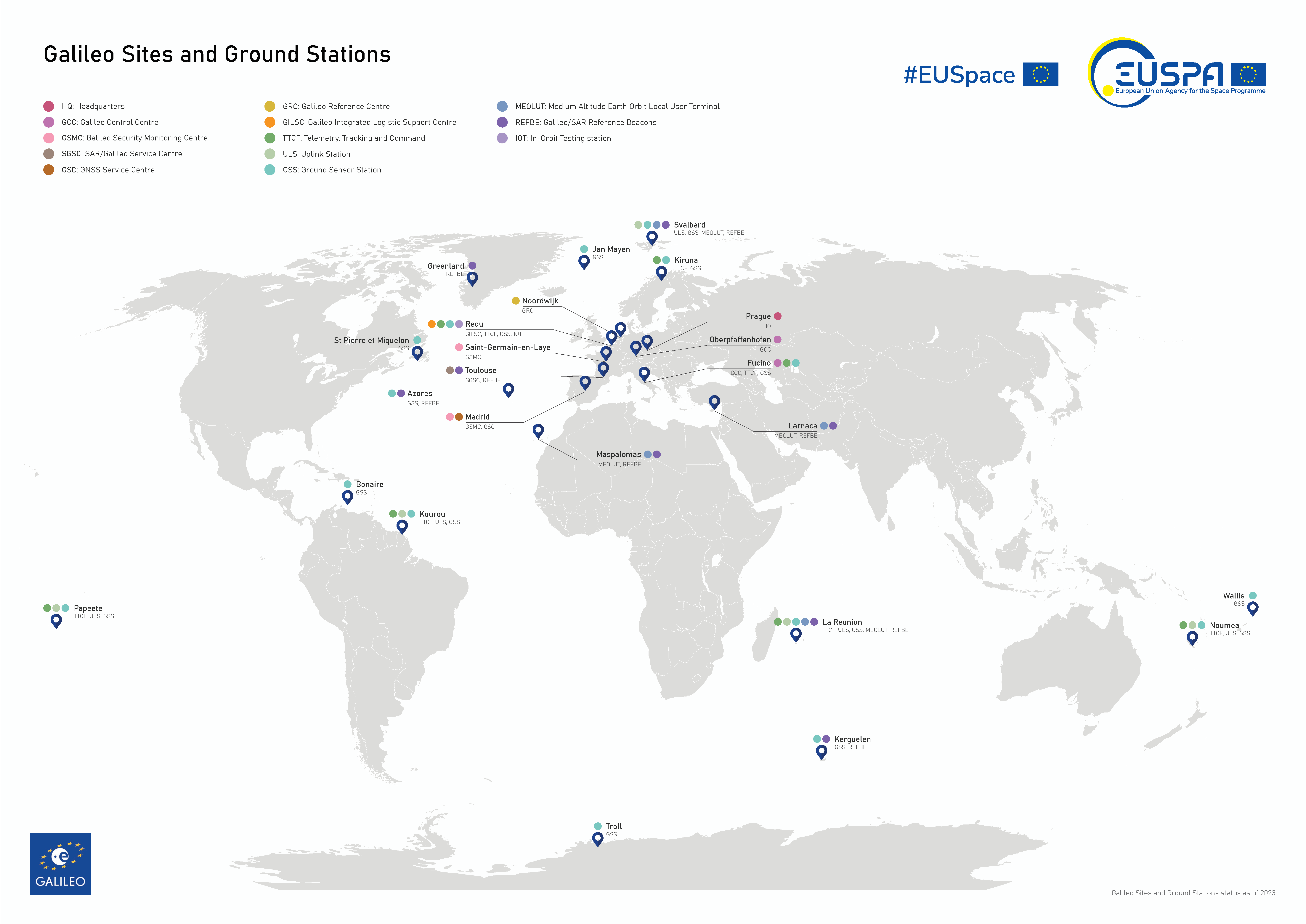
The Galileo system comprises a ground, space and user segment.
The Galileo ground segment is spread across several EU locations and consists of:
- Galileo Security Monitoring Centre
- Galileo Service Centre
- Galileo Reference Centre
- Galileo Control Centres (GCCs)
- SAR/Galileo Service Centre
These centres are complemented by a range of instruments, including sensor stations located in some of the most remote parts of the planet. These instruments check the accuracy and signal quality of individual satellites in real time and work together to pinpoint current satellite orbits.
Together, the centres and sensors play a pivotal role in delivering Galileo’s services and ensuring both the quality of signals and the overall safety of the system.
EGNOS
The European Geostationary Navigation Overlay Service (EGNOS) increases the accuracy of GNSS signals and provides a crucial integrity message informing users in the event of signal problems.
EGNOS, which stands for the European Geostationary Navigation Overlay Service, is Europe’s regional Satellite-based Augmentation System (SBAS). SBASs are used to augment the signals of Global Navigation Satellite Systems (GNSS) so that they can be used for Safety-of-Life applications such as Precision Approaches in Aviation.
Today, EGNOS uses a set of geostationary satellites and a network of ground stations to increase the accuracy of GPS. A new, more powerful system called ‘EGNOS V3’ is currently under preparation. It will strengthen both Galileo and GPS signals, resulting in an even better user experience.
As a regional navigation satellite system, EGNOS’ coverage is limited to Europe and some neighbourhood countries.
How EGNOS works
Ground stations deployed around Europe acquire signals from GPS (and, soon, from Galileo), which are then gathered and processed through a central computing system. Here, differential corrections and integrity messages are calculated. These messages are then broadcast back to users across Europe via a set of three geostationary satellites.
As a result, EGNOS improves the accuracy of GNSS positioning information while also providing a crucial integrity message, which allows the user to get an extremely reliable guarantee on its residual positioning errors (both horizontal and vertical). In addition, EGNOS signals provide the users with a very accurate synchronisation to the UTC.
Benefits
EGNOS is essential for applications where accuracy and integrity are critical, such as aviation. In fact, since its certification for use in civil aviation in 2011, EGNOS has become an important aid in the European aviation sector, increasing both the safety and accessibility of airports in general and, in particular, small and regional airports and airfields. Thanks to the accurate and safe guidance offered by the system everywhere and anytime in Europe, pilots are better positioned to land in challenging weather conditions, including poor visibility and storms, and avoid aborted landings (go-arounds).
Maritime users are also widely using EGNOS for harbour entrances, harbour approaches and coastal waters in the EU.
Beyond these sectors, EGNOS improves and extends the scope of GNSS applications in numerous market segments, including road, rail, surveying, mapping, location-based services and agriculture – to name only a few.
Infrastructure
The EGNOS infrastructure is comprised of:
- A ground network of about 40 ranging and integrity monitoring stations (RIMS)
- 6 navigation land earth stations (NLES)
- 2 mission control centres
- An Operations Coordination Centre and a Service Centre
- Signal transponders on 3 geostationary satellites operated by SATCOM service providers

Governance
EGNOS is owned by the EU citizens. The European Commission took over ownership of the EGNOS infrastructure from the European Space Agency (ESA) on behalf of the European Union on 1 April 2009. Since 1 January 2014, the European Commission has fully delegated the exploitation of EGNOS to EUSPA.
Copernicus
Copernicus is the EU's Earth Observation programme, monitoring our planet’s environment. Its services draw information from satellites and in-situ (non-space) data.
As the European Earth Observation programme, Copernicus looks at our planet and its environment and provides data and information that benefits all European citizens.
The programme consists of a complex set of systems that collect data from multiple sources, including Earth Observation satellites, in-situ sensors like ground stations, and airborne and sea-borne sensors. Users have free and open access to a great deal of this data, which is also processed to provide a set of services based on reliable and near-real time information.
Programme
Copernicus is served by a set of dedicated satellites (Sentinel family) and contributing missions (existing commercial and public satellites).
The Sentinel satellites are specifically designed to meet the needs of the Copernicus information services and their users. Since the launch of Sentinel-1A in 2014, the European Union has initiated a process to place a complete constellation of almost 20 satellites in orbit before 2030. Today, there are eight Sentinel satellites in orbit, of five different types.
Copernicus also collects information from in situ systems, such as ground stations, which deliver data acquired by a multitude of sensors located on the ground, at sea and in the air. Copernicus’ services process and analyse the wealth of satellite and in situ data, transforming it into value-added information
Copernicus is funded, coordinated and managed by the European Commission in cooperation with partners such as ESA and EUMETSAT. Meanwhile, EUSPA is responsible for promoting the commercialisation of Copernicus data and services for communities not currently reached by the Entrusted entities delivering the Copernicus services.
Benefits
Some key benefits include:
- There are 772 European companies active in the EO sector, employing 13,796 employees and generating EUR 1.796 billion in revenue
- EO market expected to grow rapidly from €3.4 billion in 2023 to almost €6 billion in 2033.
- Climate, Environmental and Biodiversity segment accounts for 22% of EO revenues.
- It is estimated that SMEs and start-ups account for nearly 96% of European Earth Observation companies.
- The European EO industry covers more than a third of the global data processing market.