Finding resiliency in the face of disaster

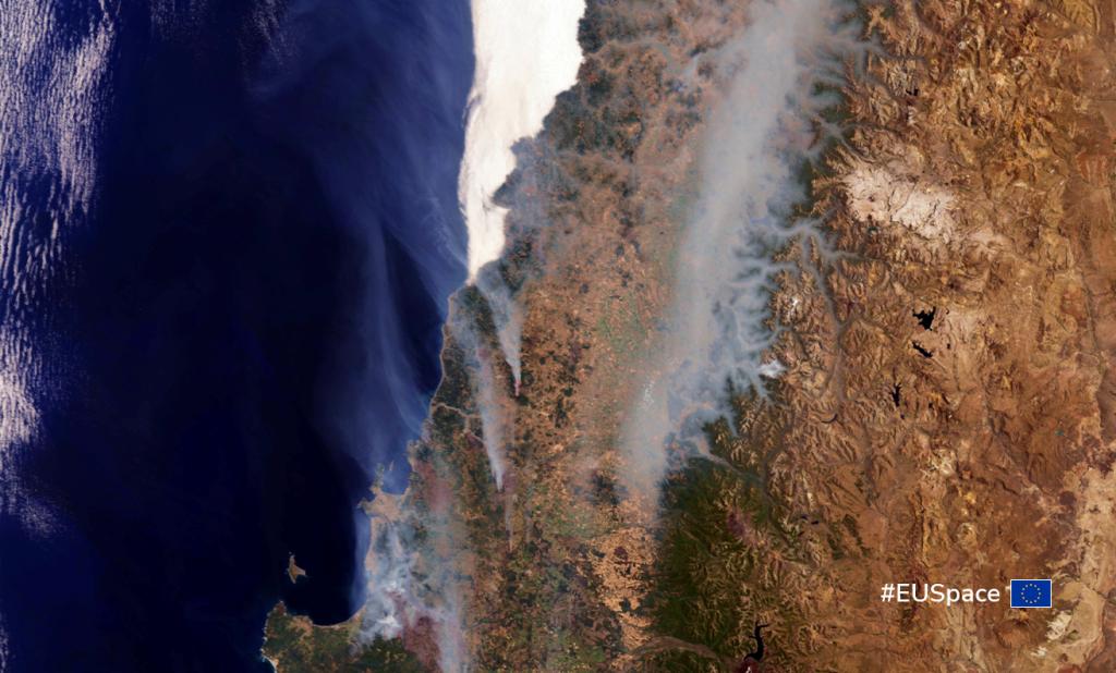
Wildfires continue to rage across Chile this week. At last count, there were 323 active fires, including at least 90 that officials consider to be out of control. Not only have they burnt an estimated 889,000 acres of forests, they’ve destroyed 1,500 homes and have left thousands homeless. At the time of writing, the wildfires have caused at least 26 deaths and more than 2,000 injuries.
Unfortunately, these fires are not an isolated incident. Wildfires happen around the world and, because of climate change, with increasing frequency and ferocity. In 2021, fires burned an area nearly two times the size of New York City in Greece, while last summer, 25% of the forests in Portugal’s famed Serra da Estrela range were lost to fire.
Whether it’s wildfires in Chile or a deadly earthquake in Turkey, natural disasters highlight the importance of having innovative tools and solutions for resilient risk management and response.
The key to building those tools and solutions? The EU Space Programme.
From GNSS (Galileo, EGNOS) to Earth Observation (Copernicus) and satellite communication (GOVSATCOM and IRIS2) , each component of the EU Space Programme brings added value to different phases of the disaster risk management and mitigation chain. For example, while firefighters and emergency first responders rely on the precise positioning provided by EGNOS and Galileo to safely guide themselves through smoke, fog and flames, Copernicus provides decision makers with critical geospatial information, including continuous observations and forecasting for flood, drought and fire risks.
Detecting and monitoring wildfires with Copernicus
Copernicus data is currently being used by decision makers in Chile to control the wildfires happening there. Specifically, ARAUCO, the country’s largest commercial forestry company, is using a solution developed by OroraTech, a German thermal-infrared data intelligence company, to track the fires’ evolution and estimate damages.
By combining satellite images provided by Copernicus with thermal infrared data, the OroraTech Wildfire Solution enables stakeholders like ARAUCO to detect and monitor wildfires better. “With space technologies, we can provide real-time data on the location, extent and behaviour of fires – information that can improve fire management and response efforts,” says Liene Lapsevska, Head of PR & Communications at OroraTech.
According to Lapsevska, the company’s technology significantly reduces fire detection time while also offering substantial cost savings over traditional detection methods like aircraft surveillance. Furthermore, its on-orbit processing capabilities will allow customers to receive data from anywhere in the world just three minutes after the satellite passes over the affected area.
OroraTech is participating in CASSINI, a EUSPA-backed initiative organised by the European Commission that supports entrepreneurs, start-ups and SMEs developing innovative applications and services that leverage the EU Space Programme.
The power of synergy and the strength of Horizon Europe
While GNSS and Earth Observation are powerful tools in their own right, the Emergency Management and Humanitarian Aid sector stands to benefit the most when these solutions are used in synergy. That’s why EUSPA is supporting such initiatives as the OVERWATCH project through Horizon Europe scheme.
The project is a collaboration between several aerospace, technology and innovation companies from across Europe. Using GNSS positioning and Copernicus data, along with such emerging technologies as Artificial Intelligence, drones, 5G connectivity and Augmented Reality, the project is building an integrated holographic management system for the response, recovery and mitigation of emergencies and disasters.
“Our goal is to provide the decision support tools authorities need to quickly deploy and manage air, water and ground assets and personnel, all integrated into an immersive and completely decentralised command platform,” explains Vanina Fissore, a researcher with the project.
The OVERWATCH system will be fed by geospatial data coming from Copernicus satellites. It will also leverage the Copernicus Emergency Management Service for the rapid mapping of a disaster area. “This data gives authorities a clear picture of the current situation, allowing them to allocate resources more efficiently and effectively,” says Katarina Spasenovic, the OVERWATCH project’s communication lead.
One of those resources is the use of drones, which are becoming an increasingly important tool in the wildfire fighting arsenal. “Unlike the ground-based systems and manned aircraft traditionally used in firefighting prevention, drones can operate over long distances, at night, in all weather conditions, in remote areas and with little to no infrastructure,” explains Vasilis Kalogirou, Space Downstream Research & Innovation Officer at EUSPA. “Proven to be effective and safe, they have the potential to be a real game-changer in firefighting missions.”
To tap this potential, OVERWATCH drones will use the precise positioning and accuracy offered by Galileo, including the recently launched Galileo High Accuracy Service, to safely navigate through a fire event. Equipped with a payload that includes sensors and cameras, these drones can serve as a valuable eye-in-the-sky during emergency situations, collecting three-dimensional data about the terrain, providing real-time tracking of a firefighter’s location in the field, and monitoring and identifying assets on the ground.
All this data, whether it be coming from Copernicus, GNSS-enabled drones or another source altogether, is then sent to the central OVERWATCH platform. Here, the data will be analysed using, at least in part, AI algorithms, which can quickly extrapolate important information that will then be presented via an intuitive, augmented reality-based user interface.
“When companies leverage the synergy of EU Space, they can help improve the speed and accuracy at which wildfires are detected and facilitate the faster, safer and more effective responses we need to contain the damage and save more lives,” concludes Kalogirou.
Media note: This feature can be republished without charge provided the European Union Agency for the Space Programme (EUSPA) is acknowledged as the source at the top or the bottom of the story. You must request permission before you use any of the photographs on the site. If you republish, we would be grateful if you could link back to the EUSPA website (http://www.euspa.europa.eu).